|


|
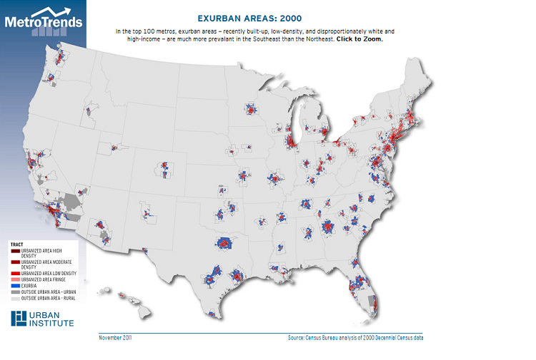
Exurbia Exurbia in 2000Recently the term "exurbia" has come into vogue, but it lacks a clear definition. Many studies have regarded growth on the metropolitan fringe as "sprawl" and have chosen characteristics to define exurbia that support this view, while other studies have made assumptions about the population and then identified areas meeting these criteria. In general, however, most researchers agree that exurbia is distinguished by rapidly growing, low-density development whose residents maintain links to neighboring urban centers. Understanding the nature of this development is important because exurbia houses an increasing proportion of the U.S. population, especially those whose affluence affords them a high degree of residential choice. Our analysis defines exurban census tracts by focusing on three aspects of the built environment without making any assumptions about the characteristics of the inhabitants of exurbia. We first identify tracts with housing unit densities ranging from 16 to 256 units per square mile, which corresponds to an average of between 2.5 and 40 acres per unit. This range captures those tracts with a lower housing unit density than areas typically regarded as urban or suburban, but with a higher housing unit density than areas dominated by farmland. Second, we consider the age of the housing stock, selecting tracts in which the majority of housing units have been built within the preceding 20 years-- that is, rapidly growing areas where the median year of construction of the housing units is 1980 or later. Finally, we determine which of these tracts are linked to neighboring urban centers using commuting rates. In order to qualify as exurban, at least 25 percent of the employed residents of a tract must commute to an urban core with a population of at least 50,000. In this way, we can distinguish between established, self-contained small towns in outlying parts of metro areas from recent developments that have strong links to nearby urban centers. Applying this methodology to tract-level data from Census 2000, we find that exurban areas are common nationwide but, for a number of reasons, they are not evenly distributed across the country. For example, restrictive zoning laws can inhibit the growth of exurbia (Portland), as can terrain such as mountains (Los Angeles), deserts (Las Vegas), or coastal areas (Boston). Also, some densely populated areas lack available hinterlands (New York, Philadelphia). There is also regional variation in the pattern of exurban development. In the Northeast, exurbia is not particularly widespread, mainly because of the dense megalopolis development along the Boston-New York-Philadelphia-Baltimore-D.C. corridor. The metropolitan areas of upstate New York, Pennsylvania, and Ohio also have very few exurbs. In the Southeast, on the other hand, most metropolitan areas of any size have an extensive exurban ring, likely due to rapid population growth, a lack of geographic constraints, and favorable zoning laws, all of which combine to allow unimpeded development. The pattern is less clear-cut west of the Mississippi River. Large cities in Texas are surrounded by exurbia; in fact, the exurban rings of San Antonio and Austin have grown together to form a continuous string of low-density development along the I-35 corridor. In California and other western states, most metropolitan areas have some exurban development, but it is not nearly as extensive as it is in Texas or the Southeast. The Atlanta and Chicago metropolitan areas illustrate just how disparate exurban development can be. In metropolitan Atlanta, over one third of the land area is exurban, and the exurbs completely encircle the urban core. Compare this to metropolitan Chicago, where less than ten percent of the land area is exurban, and where the exurbs are limited to a few tracts west and south of the city that do not cohere into a well-defined pattern. Although the population of the Atlanta metro area is less than half that of the Chicago metro area (4.2 million vs. 9.2 million), metropolitan Atlanta's exurban population is well over three times that of metropolitan Chicago's (756,000 vs. 201,000). Proportionally, the disparity is even greater: The exurbs house 17.8 percent of metropolitan Atlanta's population, compared to only 2.2 percent of metropolitan Chicago's. Nationwide, exurban areas house about 5.6 percent of the population. Exurbia is disproportionately populated by non-Hispanic whites, who make up 81.9 percent of the population of these areas, compared with 69.2 percent in the general population. Exurban residents also have higher incomes and are more likely to own their homes than people residing in other areas. Furthermore, exurban residents are more auto-dependent than people residing elsewhere. Nearly three quarters of exurban households own at least two cars, substantially higher than the national rate of 55.5 percent. Exurban workers have longer commutes, too. Over 42 percent of exurban commuters have a journey to work of 30 minutes or more. Although we have only provided point-in-time estimates, analyzing trends in exurban development is also important. We plan to apply this methodology to the 2010 census and American Community Survey as these datasets become available, as well as previous decennial censuses. Tracking the changes in this type of low-density growth will be useful to transportation planners and other service providers. This work is released to inform interested parties of ongoing research and to encourage discussion of work in progress. Any views or opinions expressed in the paper are the authors' own and do not necessarily reflect the views or opinions of the U.S. Census Bureau. |
Experts Feedback
Send us your comments to help further the discussion. Share
Commentaries
|